America's Lost Superpower: When Everyone Actually Knew Where They Were Going
America's Lost Superpower: When Everyone Actually Knew Where They Were Going
Pull over and ask any American under 30 which direction is north. Watch them fumble for their phone, open a mapping app, and still look confused. Now imagine explaining to them that their grandparents could navigate cross-country with nothing but a folded paper map, a compass, and an internalized understanding of how highways, geography, and cardinal directions actually worked.
We've become a nation of navigationally illiterate people who can summon turn-by-turn directions to any address on Earth but couldn't find their way home if their phone died. This isn't just about technology replacing an old skill—it's about the quiet disappearance of spatial intelligence that once defined what it meant to be a competent adult.
When Maps Were Skills, Not Apps
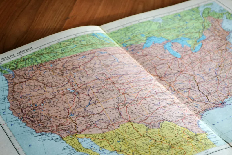
Every car manufactured before 1995 came with a glove compartment specifically sized to hold folded road maps. These weren't decorative accessories—they were essential survival tools that required genuine skill to use effectively.
Reading a road map demanded multiple layers of spatial reasoning. You had to understand scale, interpret topographical symbols, and mentally translate two-dimensional representations into three-dimensional reality. More importantly, you had to think several moves ahead, plotting entire routes before starting your engine.
The experienced map reader could glance at a state highway map and immediately understand traffic patterns, elevation changes, and logical connection points between distant cities. They could estimate travel times based on road types, predict where construction might cause delays, and identify alternative routes before problems arose.
This wasn't just navigation—it was strategic thinking applied to geography. The best drivers carried multiple maps at different scales: detailed city maps for urban navigation, state maps for regional travel, and national atlases for cross-country trips. They understood how these different perspectives connected and could seamlessly transition between them as needed.
The Art of Dead Reckoning
Pre-GPS drivers developed an almost supernatural ability to maintain spatial awareness while traveling. They could sense when they were heading generally north or south, east or west, even on winding roads or during cloudy weather. This wasn't magic—it was the result of constantly paying attention to sun position, mountain ranges, major highways, and other geographic landmarks.
Long-distance drivers became human compasses, able to navigate by feel across vast stretches of unfamiliar territory. They memorized highway numbering systems (odd numbers run north-south, even numbers run east-west), understood how Interstate highways connected to each other, and could dead-reckon their approximate position even in completely unknown areas.
This spatial intelligence extended beyond just driving. People naturally developed mental maps of their cities, regions, and country. They could sketch rough directions on napkins, give coherent verbal directions without consulting any external source, and maintain situational awareness in ways that seem almost superhuman today.
When Getting Lost Was Educational
Modern GPS has eliminated the possibility of productive mistakes. When your phone tells you exactly where to turn, you never develop the problem-solving skills that come from figuring out where you are when things go wrong.
Pre-GPS drivers regularly got lost, and that experience taught crucial navigation skills. Being genuinely lost forced you to study your surroundings, read street signs carefully, and develop hypotheses about your location that you could test and refine. You learned to recognize patterns in how cities were laid out, how highway systems connected, and how to use landmarks for orientation.
Getting unlost required active engagement with your environment. You'd pull over to study your map, ask directions from gas station attendants who actually knew the local area, and develop backup plans for when your primary route didn't work out. These weren't just navigation skills—they were general problem-solving abilities that transferred to other areas of life.
The confidence that came from successfully navigating out of a difficult situation was genuine and lasting. You'd proven to yourself that you could handle uncertainty, think spatially under pressure, and find solutions using only your wits and basic tools.
The Death of Spatial Awareness
Today's turn-by-turn navigation has created a generation of passive passengers who follow voice commands without understanding where they're going or why. The average GPS user couldn't retrace their route without guidance, couldn't estimate how long alternate routes might take, and has no mental model of how their daily travels connect to the broader geography around them.
This isn't just inconvenient—it's cognitively limiting. Spatial intelligence appears to be connected to other forms of abstract thinking, mathematical reasoning, and problem-solving ability. When we outsource all navigation to algorithms, we may be weakening mental muscles that we don't even realize we're using.
Modern drivers often can't estimate distances, don't notice cardinal directions, and have no intuitive sense of where they are in relation to major landmarks, highways, or geographic features. They've become completely dependent on external guidance for tasks that previous generations handled automatically.
What We Lost in the Translation
GPS navigation is undeniably superior in most practical ways. It's faster, more accurate, and can adapt to real-time traffic conditions in ways that paper maps never could. It's democratized travel by making navigation accessible to people who might have struggled with traditional map reading.
But the old system taught skills that went far beyond just finding your way from point A to point B. It required constant attention to your environment, developed spatial reasoning abilities, and created a sense of geographic literacy that connected people to the physical world around them.
The pre-GPS driver understood their place in space in a way that today's travelers simply don't. They could tell you which states they'd driven through, which mountain ranges they'd crossed, and how their route connected to the broader transportation network. They possessed genuine geographic knowledge rather than just the ability to follow directions.
The Confidence of True Navigation
Perhaps most importantly, the old system created genuine confidence and self-reliance. The driver who could navigate cross-country with a paper map possessed a form of independence that's become almost extinct. They could venture into unknown territory with the confidence that they could find their way, adapt to changing conditions, and solve problems as they arose.
This confidence wasn't just about driving—it was about being a competent adult in a complex world. The same spatial reasoning skills that helped you navigate unfamiliar cities also helped you think through complex problems, understand abstract relationships, and maintain awareness of your position in both physical and metaphorical space.
We've traded this hard-won competence for the convenience of never having to think about where we're going. It's probably a fair trade in most practical terms, but it's worth acknowledging what we've lost: the quiet satisfaction of truly knowing where you are, where you're going, and how to get there using nothing but your own spatial intelligence and a folded piece of paper.
That knowledge made Americans more than just drivers—it made them navigators in the truest sense, people who could read the landscape and find their way through the world with confidence and skill.